This world is filled with unlimited natural beauty, mysterious and strange places. These strange looking places and landscapes in the world are the result of
continuous natural erosion, have millions of years of age. Most of the
keep changing their structure by time, and most of them gets more mysterious. Here below Top 10 Most Strangest places of the world listed, Read on;
Top 10 Most Strangest places in the world
1. Zhangjiajie National Forest Park
The Zhangjiajie National Forest Park is a unique national forest park located in Zhangjiajie City in northern Hunan Province in the People's Republic of China. It is one of several national parks within the Wulingyuan Scenic Area. Zhangjiajie National Park covers 185 square miles of area. The narrow sandstone pillars becomes the main attraction of this national park, formed from millions of years of natural erosion. Each pillars differs y size, highest pillar in this national park have 650 feet height. It is also recognized as UNESCO’s world heritage site. Zhangjiajie also became home for many rare animal and plant species. It is possible to rare white flowered trees which is originally appears on Earth before 205 million years ago. There are 100 different types of vertebrates are securely living inside this national park.
2. Uluru
Uluru also known as Ayers Rock is a large sandstone rock formation in the southern part of the Northern Territory in central Australia. Uluru is sacred to the Anangu, the Aboriginal people of the area. The area around the formation is home to an abundance of springs, waterholes, rock caves, and ancient paintings. Uluru is listed as a UNESCO World Heritage Site. Uluru is one of Australia's most recognizable natural landmarks. The sandstone formation stands 348 m (1,142 ft) high, rising 863 m (2,831 ft) above sea level with most of its bulk lying underground, and has a total circumference of 9.4 km (5.8 mi). Both Uluru and the nearby Kata Tjuta formation have great cultural significance for the Aṉangu people, the traditional inhabitants of the area, who lead walking tours to inform visitors about the local flora and fauna, bush foods and the Aboriginal dream-time stories of the area.
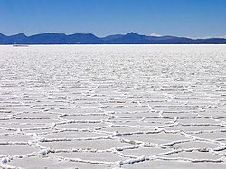
3. Salar de Uyuni
Salar de Uyuni is the world's largest salt flat at 10,582 square kilometers (4,086 sq mi). It is located in the Daniel Campos Province in Potosí in southwest Bolivia, near the crest of the Andes and is at an elevation of 3,656 meters (11,995 ft) above mean sea level. The Salar was formed as a result of transformations between several prehistoric lakes. It is covered by a few meters of salt crust, The crust serves as a source of salt and covers a pool of brine, The salt deposit spread across a wide area of 10582 square kilometers, contains 10 billion tons of salts. Whenever this area covered by water it becomes largest natural mirror
on Earth. At that time it reflects sky, clouds and everything above the
surface. This flat stable surface does not change over time, NASA uses
this property of salar de uyuni to calibrate the satellites. It contains 50 to 70% of the world's lithium reserves.
4. Giant’s Causeway
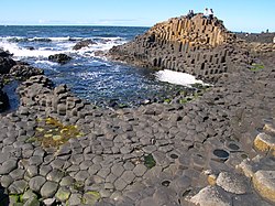
The Giant's Causeway is an area of about 40,000 interlocking basalt columns, the result of an ancient volcanic eruption. It is located in County Antrim on the northeast coast of Northern Ireland, about three miles northeast of the town of Bushmills. It was declared a World Heritage Site by UNESCO in 1986, and a national nature reserve in 1987 by the Department of the Environment for Northern Ireland. In a 2005 poll of Radio Times readers, the Giant's Causeway was named as the fourth greatest natural wonder in the United Kingdom. The tops of the columns form stepping stones that lead from the cliff foot and disappear under the sea. Most of the columns are hexagonal, although there are also some with four, five, seven or eight sides. The tallest are about 12 metres high, and the solidified lava in the cliffs is 28 metres thick in places. Much of the Giant's Causeway and Causeway Coast World Heritage Site is today owned and managed by the National Trust and it is one of the most popular tourist attractions in Northern Ireland.
5. Fly Geyser
Fly Geyser, also known as Fly Ranch Geyser is a man-made small geothermal geyser located in Washoe County, Nevada approximately 20 miles north of Gerlach. Fly Geyser is located near the edge of Fly Reservoir in the Hualapai Geothermal Flats and is only about 5 feet high, by 12 feet wide, counting the mound on which it sits. The source of the Fly Geyser field's heat is attributed to a very deep pool of hot rock where tectonic rifting and faulting are common. Fly Geyser is not an entirely natural phenomenon; it was accidentally created by well drilling in 1964 exploring for sources of geothermal energy. Water is constantly released, reaching 5 feet in the air. The geyser contains several terraces discharging water into 30 to 40 pools over an area of 74 acres. The geyser is made up of a series of different minerals, but its brilliant colors are due to thermophilic algae.
6. Kīlauea
Kīlauea is a currently active shield volcano in the Hawaiian Islands, and the most active of the five volcanoes that together form the island of Hawaiʻi. Located along the southern shore of the island, the volcano is between 300,000 and 600,000 years old and emerged above sea level about 100,000 years ago. Structurally, Kīlauea has a large, fairly recently formed caldera at its summit and two active rift zones, one extending 125 km (78 mi) east and the other 35 km (22 mi) west, as an active fault of unknown depth moving vertically an average of 2 to 20 mm (0.1 to 0.8 in) per year. Kilauea having a continuous eruption since 1983, lava also flows in to
Pacific ocean, becomes one of most stunning view of nature.
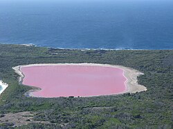
7. Lake Hillier
Lake Hillier is a saline lake on the edge of Middle Island, the largest of the islands and islets that make up the Recherche Archipelago in the Goldfields-Esperance region, off the south coast of Western Australia. It is particularly notable for its pink colour. A long and thin shore divides the Southern Ocean from the lake.Lake Hillier is about 600 metres in length by about 250 metres in width. The lake is surrounded by a rim of sand and a dense woodland of paperbark and eucalyptus trees with a narrow strip of sand dunes covered by vegetation separating its northern edge from the northern coast of Middle Island. The most notable feature of the lake is its pink color. The vibrant color is permanent, and does not alter when the water is taken in a container. From above, the lake appears a solid bubble gum pink, but from the
shoreline it appears more of a clear pink hue. The shoreline is also
covered in salt crust deposits.
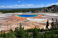
8. Grand Prismatic Spring
The Grand Prismatic Spring in Yellowstone National Park is the largest hot spring in the United States, and the third largest in the world, after Frying Pan Lake in New Zealand and Boiling Lake in Dominica. It is located in the Midway Geyser Basin. Grand Prismatic Spring was noted by geologists working in the Hayden Geological Survey of 1871, and named by them for its striking coloration. Its colors match the rainbow dispersion of white light by an optical prism: red, orange, yellow, green, and blue. The first records of the spring are from early European explorers and surveyors. In 1839, a group of fur trappers from the American Fur Company crossed the Midway Geyser Basin and made note of a "boiling lake", most likely the Grand Prismatic Spring, with a diameter of 300 feet. The spring is approximately 370 feet (110 m) in diameter and is 121 feet (40 m) deep. The spring discharges an estimated 560 US gallons (2,100 L) of 160 °F (70 °C) water per minute.
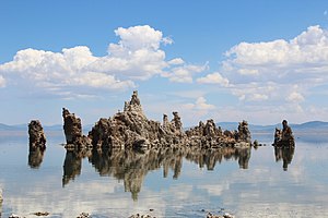
9. Mono Lake
Mono Lake is a large, shallow saline soda lake in Mono County, California, formed at least 760,000 years ago as a terminal lake in an endorheic basin. The lack of an outlet causes high levels of salts to accumulate in the lake. The water of mono lakes also shows some kind of mysterious behavior,
very thick and oily, makes a slippery experience on touch. It’s water
contains lots of salt and baking soda. These salts also make the lake water alkaline. The limnology of the lake shows it contains approximately 280 million tons of dissolved salts, with the salinity varying depending upon the amount of water in the lake at any given time. Mono Lake occupies part of the Mono Basin, an endorheic basin that has no outlet to the ocean. Dissolved salts in the runoff thus remain in the lake and raise the water's pH levels and salt concentration
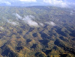
10. Chocolate Hills
The Chocolate Hills are a geological formation in the Bohol province of the Philippines. There are at least 1,260 hills but there may be as many as 1,776 hills spread over an area of more than 50 square kilometres (20 sq mi). They are covered in green grass that turns brown (like chocolate) during the dry season, hence the name. The Chocolate Hills are a famous tourist attraction of Bohol. They are featured in the provincial flag and seal to symbolize the abundance of natural attractions in the province. They are in the Philippine Tourism Authority's list of tourist destinations in the Philippines; they have been declared the country's third National Geological Monument and proposed for inclusion in the UNESCO World Heritage List.
So what you think about this list don't forget to mention :)


-crop.jpg/250px-Uluru_(Helicopter_view)-crop.jpg)


0 comments:
Post a Comment